IBM’s beta release of its Environmental Intelligence (EI) platform offers application developers and data scientists curated environmental insights powered by AI with access to open-source geospatial and satellite data.
This cloud-based platform provides a variety of geospatial, weather, and climate APIs, enabling users to create applications that address sustainability, climate change, and regulatory needs.
IBM aims for the software to help businesses manage financial risks associated with climate disruptions. Both public and private sectors face climate-related challenges, including operational disruptions, asset damage, and supply chain vulnerabilities. IBM Environmental Intelligence offers geospatial data, advanced models, and AI insights to support organizations in addressing these critical issues.
“Environmental Intelligence is a new product, but some of its remnants date back several years. We have a very wide IBM research community of sustainability and climate scientists who are investing and working with specific industry type problems, climate type problems that are really forward-thinking,” David Blanch, director of product management, ESG, and Environmental Intelligence at IBM, told TechNewsWorld.
Versatile API Suite Powers Environmental Insights
IBM’s EI solution offers a suite of APIs to help developers and data scientists gather and analyze Earth’s surface data for predictive insights and proactive decision-making. It simplifies the process of working with public satellite data by processing, normalizing, and organizing it into geospatial layers, making it ready for analysis and visualization.
Satellite imagery highlighting biomass data to support environmental monitoring and sustainability initiatives.
The APIs and a Python software development kit (SDK) provide access to high-resolution imagery, global weather data, and other valuable datasets to gain insights for quicker action. The EI platform features a foundation model co-developed with NASA for pre-processing and cleansing geospatial data.
Other key features include seamless access to environmental and geospatial datasets through easy-to-use APIs for real-time analysis. Geospatial-temporal querying uses an advanced insights engine to analyze geospatial and temporal data and improve application functionality.

IBM’s Environmental Intelligence platform features data layers, predictive models, and insights to support decision-making and sustainability efforts.
On-demand historical weather data provides access to past weather data to inform predictive models and optimize operations across various sectors. Advanced data querying lets users execute complex queries on diverse environmental datasets at customizable spatial and temporal resolutions.
APIs automate greenhouse gas (GHG) emissions calculations for the internal and supply chain emissions to track and manage carbon footprints.
The beta platform is free. IBM will consider future pricing and packaging decisions pending market feedback.
Market Trends Show New Uses for Climate Data
IBM is targeting a specific audience of technical builders, developers, and data scientist communities because of observed trends in the market. According to Blanch, these targeted users are not necessarily all climate scientists or meteorologists who benefit from accessing the innovative data, putting it behind an API, and applying embeddable use cases across their existing applications.
The trends involve how climate change is impacting business operations across various verticals. Research indicates that climate-related disasters are causing significant losses on a macro level. Some of the datasets within environmental intelligence fall into a couple of buckets.
One dataset is open-source satellite imagery, offering high-resolution visuals captured by European satellites orbiting the globe every five days. This imagery supports a wide range of applications, from environmental monitoring to regulatory compliance.
“An organization could access that raw imagery on its own but would encounter a lot of challenge with pre-processing cloud removals,” noted Blanch in a key benefit of using the EI platform instead.
Another dataset includes meteorological data such as historical records, real-time updates, and short-term weather forecasts. Blanch noted that climate projections for more long-term needs involving climate planning should be added to those scenarios.
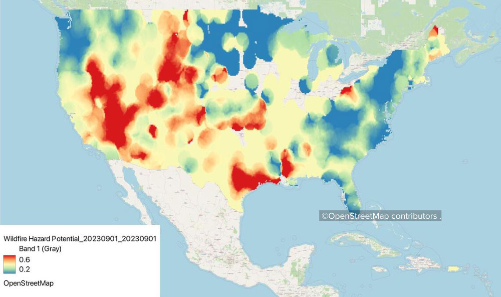
Thinking in terms of specific business examples, how do you build more resiliency inside your organization regarding natural hazards like floods and wildfires? How do you handle disaster risk planning and risk assessments? How do you calculate your business’s carbon emissions?

Visualizing wildfire risk across regions using IBM’s Environmental Intelligence platform for disaster planning and resiliency.
“If you think about how companies are operationalizing sustainability, they have an industrial asset and a methane link to a carbon equivalent in today’s workflow. A work order might be issued so that somebody can go perform some maintenance for these different operational groups who are not traditional sustainability-minded people,” Blanch suggested.
Sustainability Solutions for Diverse Industries
According to Blanch, IBM wants to expand beyond traditional uses to benefit the potential applications in other industries. He referenced use cases already showing EI success in agriculture, such as crop monitoring, yield prediction, and precision farming.
For example, easier access to satellite data is helping organizations comply with new environmental regulations from governments. The European Union’s deforestation regulation is a case in point.
It requires companies to review their supply chains and verify they are not working with suppliers who violate these regulatory requirements involving extensive land use changes.
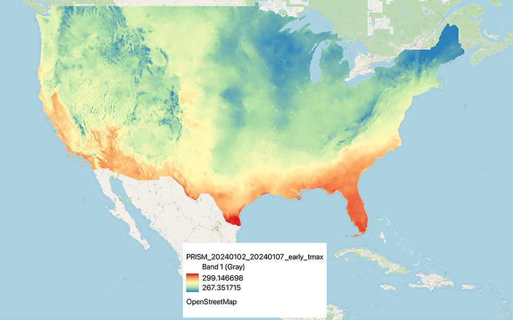
Another example involves how IBM’s EI technology can impact animal growth and influence nutrition adjustments based on environmental conditions. Some groups developed a predictive modeling system using weather data to assess mycotoxin levels in their crops. They were able to create a forecasting model using environmental and weather data from the platform to improve their business operations.

Temperature distribution map aiding predictive modeling for agriculture and climate-related decision-making.
“The potential for third-party, remote imaging is tremendous. So you don’t need to be meteorologists or climate experts, but you can have access to a pre-processed, curated data set that could be available with easy tutorials, samples, and guides to embed those within your applications, models, or workflows,” Blanch said about the goal of IBM’s EI software.
The OpenStreetMap images in this article were provided to TechNewsWorld courtesy of IBM.
Read the full article here


