



Dozens of rural and forest fires broke out in Greece within 24 hours, while gale-force winds made firefighting operations difficult in many parts of the country.
ADVERTISEMENT


ADVERTISEMENT
From 18:00 on Tuesday to 18:00 on Wednesday, the Greek Fire Service recorded 37 rural and forest fires. Thirty were tackled immediately, while operations were still under way in seven cases. The most serious fronts were in southern Crete and in Plomari on Lesbos, in the northern Aegean.
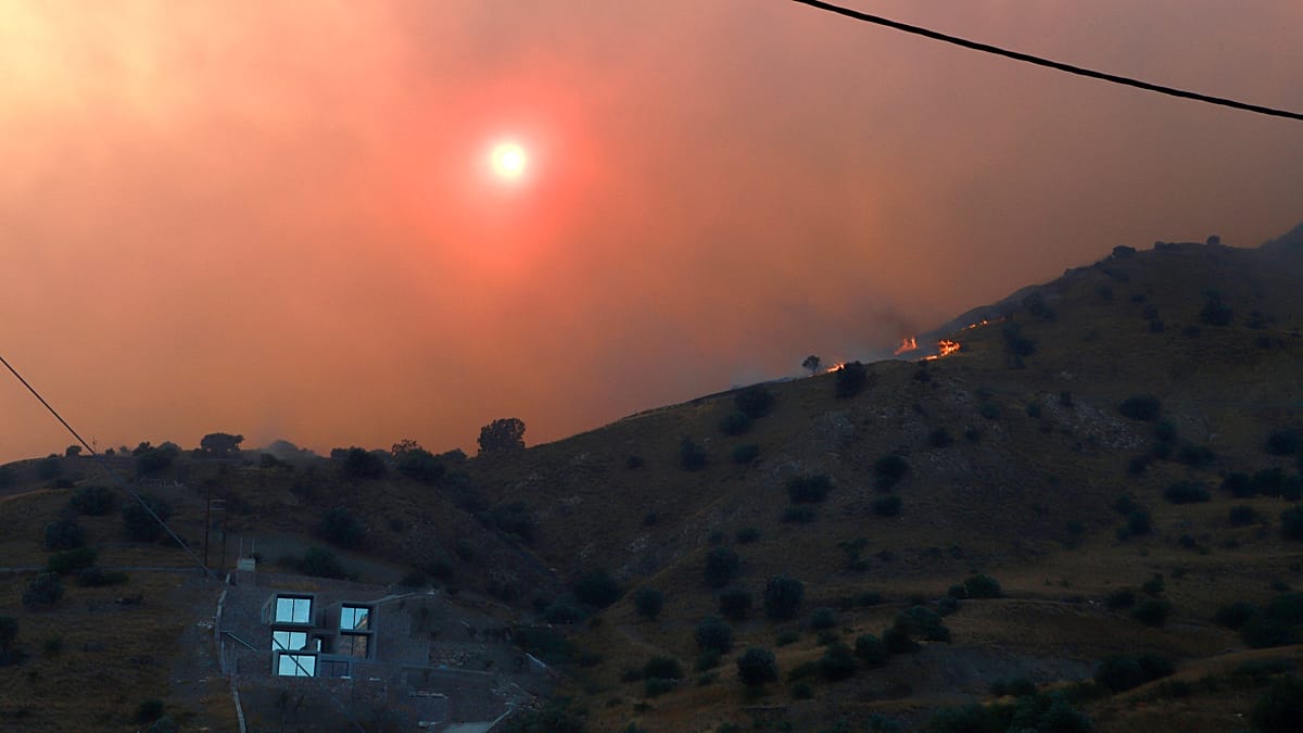
The largest and most challenging fire was still burning on Thursday morning in southern Rethymno, where two firefighters lost their lives during the operation. The blaze triggered evacuations of villages and tourist areas and caused damage to homes, crops, and livestock facilities, while strong winds significantly limited the ability of aerial assets to intervene.
Fire in southern Rethymno out of control
The fire broke out at around 14:30 on Wednesday in low vegetation near Krya Vrysi, in the municipality of Agios Vasileios, on the southern side of Crete.
Driven by very strong northerly winds, the flames spread rapidly towards settlements and tourist areas along the southern coast of Rethymno, including Melambes, Sachtouria, Kryopetra, Agios Pavlos, Agios Georgios, Orne and Agia Galini.
On Thursday morning, officials from the Region of Crete said the total active front exceeded 15 kilometres. The full perimeter of the fire and the extent of the burned land had not yet been officially calculated.
Maria Lioni, deputy regional governor of Rethymno, spoke of a “nightmare night and nightmare day”, stressing that the damage is extensive but a full assessment cannot be carried out while the fire is still burning.
More than 220 firefighters on the ground
The operation involves 224 firefighters, 11 specialised forest firefighting units on foot and 53 fire engines, along with volunteers.
The on-foot units come from the Special Forest Operations Units, the Fire Service’s specialised teams that operate on foot in forested and hard-to-access areas. Reinforcements arrived in Crete by ferry from mainland Greece on Thursday morning.
The operation is being supported by water tankers and heavy machinery from the municipality of Agios Vasileios, the Region of Crete, neighbouring municipalities and private owners.
Seven ambulances from the National Emergency Aid Centre remain on standby in the wider area of Krya Vrysi, Orne and Agia Galini.
The mobilisation also involves the Hellenic Police and the Hellenic Coast Guard.
Winds hinder aerial operations
Two helicopters had been deployed for aerial firefighting, but the very strong winds did not allow them to safely carry out continuous water drops on Thursday morning.
Aerial assets had operated for a limited period on Wednesday but were forced to withdraw when conditions deteriorated.
According to the regional authorities, winds on the southern side of Rethymno reached 10 to 11 on the Beaufort scale in places. Weather stations of the National Observatory of Athens recorded gusts exceeding 100 kilometres per hour.
Ground forces worked throughout the night to contain scattered hotspots and prevent the fire from spreading towards inhabited areas.
Homes, crops and livestock units burned
Initial reports speak of damage to homes, farms, arable land, pasture and livestock facilities. Animal losses have also been recorded.
There is still no official overall count of destroyed homes or agricultural installations, nor a confirmed estimate of the burned area. Local authorities stress that the assessment will begin once safe access to the affected areas is possible.
Successive evacuation orders
The Greek emergency service 112, which sends mass warning messages to mobile phones of people located in a dangerous area, was activated repeatedly from Wednesday afternoon.
In total, six warning messages were sent from the time the fire broke out, most of them urging residents and tourists to evacuate the hazardous areas.
Agia Galini, a tourist settlement on Crete’s southern coast, was evacuated in an organised manner by land, with the assistance of the police.
According to Maria Lioni, around 8,000 residents and visitors were moved out of the area. This figure is an estimate by the regional administration and not a final count of those displaced.
The Coast Guard also carried out operations to evacuate residents and tourists by sea from Agios Pavlos and Triopetra, as buses couldn’t reach these areas via the road network. The published figures for the number of people transported by boat vary, so there is not yet a reliable, single total.
Temporary shelter in a sports hall and hotels
About 700 people were taken to the indoor sports hall of the municipality of Phaistos, in Moires in Heraklion, where beds, mattresses and basic necessities had been set up. Other visitors were transferred, with the assistance of travel agencies and hotel operators, to available accommodation in safe areas of Crete.
The municipal authorities had also placed school buildings on standby in case additional shelter space was required.
“We welcomed the people who were forced to leave. Some departed under the care of travel agencies, but most were accommodated here,” said Phaistos mayor Grigoris Nikolidakis, adding that beds, clean sheets, food and other essentials were brought in.
The Ministry of Tourism, in cooperation with the Hellenic Chamber of Hotels, also activated a special online platform to provide temporary accommodation for those forced to abandon their homes or tourist lodgings.
Funerals of the two firefighters held today
Meanwhile, Rethymno and the municipality of Amari are bidding farewell on Thursday to the two firefighters who lost their lives during the operation at Krya Vrysi.
They are 25-year-old seasonal firefighter Pantelis Diamantakis and 58-year-old firefighter on a five-year contract Emmanouil, known as Manolis, Stratidakis. Both were from the Amari area.
The Fire Service has confirmed that the two men died while taking part in the firefighting operation. The exact circumstances in which they became trapped have not yet been set out in a detailed official report.
The smoke plume travelled 100 kilometres south
The fire was recorded by Meteosat-12, a European weather satellite operated by the European Organisation for the Exploitation of Meteorological Satellites.
The satellite image showed the approximate location of the fire and the plume, the extensive column of smoke.
The smoke, not the fire itself, was carried by the winds around 100 kilometres southwards, over the sea. The image was analysed by the scientific team of the National Observatory of Athens.
Plomari: No single active front, but fire not yet contained
In Plomari on Lesbos, the situation was improving on Thursday morning, with no single continuous active front. However, the fire had not yet been declared contained, as flare-ups were ongoing and strong northerly winds were keeping the risk of renewed spread high.
The overnight operation focused on preventing the fire from spreading into unburned areas and extinguishing hotspots within olive groves. Burning olive trees and the difficult terrain make full extinguishing of the hotspots harder.
More than 1,000 stremmas — roughly 100 hectares — have burned, mainly olive cultivation and pine forest.
Ninety-two firefighters, five specialised forest firefighting units on foot and 19 vehicles are operating in the area, together with volunteers.
The on-foot units include 34 firefighters, 20 of whom were brought in from Thessaloniki, in northern Greece, to reinforce local forces.
With the first light of day, targeted water drops by aerial assets resumed. The goal was to limit flare-ups before the winds were expected to strengthen after midday.
Northerly winds intermittently exceeded force eight on the Beaufort scale, increasing the risk of embers being carried into areas that had not burned.
After the fire broke out, an emergency message from 112 was sent for the precautionary relocation of residents and visitors towards Agios Isidoros.
The air over Lesbos was also burdened by smoke transported across the Aegean from multiple fires along Turkey’s western coast. The movement of this smoke towards Lesbos was likewise recorded by Meteosat-12.
Very high wildfire risk in much of Greece
A very high risk of wildfire (risk category 4) is forecast for today, Thursday, in Attica, Crete, the Cyclades, islands of the Region of Northern Aegean and many areas of the Regions of Peloponnese and Central Greece, according to the Wildfire Risk Forecast Map issued by the General Secretariat for Civil Protection of the Ministry of Climate Crisis and Civil Protection.
Specifically, a very high risk of wildfire is forecast today for the following areas:
* Region of Attica (including the island of Kythira)
* Region of Peloponnese (Regional Units of Corinthia, Argolida, Arcadia, Laconia)
* Region of Central Greece (Regional Units of Boeotia, Fthiotida, Fokida, Evia including the island of Skyros)
* Region of Northern Aegean (Regional Units of Lesbos, Chios, Samos, Ikaria)
* Region of Southern Aegean (Regional Units of the Cyclades)
* Region of Crete
The General Secretariat for Civil Protection of the Ministry of Climate Crisis and Civil Protection has informed the competent state services involved, as well as the Regions and Municipalities of the above areas, so that they remain on heightened civil protection alert in order to respond immediately to any wildfire incidents.
At the same time, the General Secretariat for Civil Protection urges citizens to be particularly careful and to avoid activities in the countryside that could cause a fire through negligence, such as burning dry grass and branches or cleaning residues, using machinery that produces sparks such as circular saws and welding equipment, using outdoor barbecues, smoking out bees, throwing lit cigarettes, etc. It also reminds the public that burning fields is prohibited during the fire season.
If they detect a fire, citizens are asked to immediately notify the Fire Service by calling 199.
For more information and self-protection guidelines against the dangers of forest fires, citizens can visit the website of the General Secretariat for Civil Protection at the address civilprotection.gov.gr.
Read the full article here